 The objectives of this flight: 1) enroute IFR procedures, 2) non-precision approach, and 3) that $100 Hamburger.
It looked like the planets had aligned and weather gods had finally agreed to allow us to venture west to Pell City (KPLR) in St Clair County, Alabama! While we had originally scheduled the airplane for 9:00 am local, we decided to wait for the remains of the windy cold front to completely pass and rescheduled for 3:00 pm. I arrived about an hour early so we could brief and do a final weather check. I had filed IFR from home (still very cool, although the AOPA Real-Time Flight Planner was down due to a Jeppesen server problem). The weather was very clear and not an issue. I decided to exercise some cockpit management and asked the Safety Pilot if he would handle all communications during the flight. (Since he is working toward his IFR rating it would give him some experience talking to the controllers, and with some reservations, he agreed.)
 I filed Dalas/V325/GAD/STAMP/KPLR which uses STAMP as the feeder fix for the GPS RWY 20 into Pell City. I warned the copilot to expect HEFIN with V321 up to GAD and that was what was given. Clearance Delivery warned us of an annoying whine on our radio, and without missing a beat my copilot said he would tell "the pilot to keep it down". Earned him a chuckle from them and a snarl from me. Runup and take off went fine, although it took a little longer then normal for Tower to hand us off to ATC. Level at 6000 we were getting bounced around a bit, so I had the copilot ask for 8000, which is pretty high for this old bird, but she was able to maintain a 500 fpm rate. It was smooth at 8k and just about above the scattered layer. It was fun to slice a few of the wisps up there. We were cleared "our own navigation" direct GAD. We passed about 10 miles south of Cedartown (4A4) and heard the "getting ready to unload" message from the Sky Divers there. (Maybe Nate?)
During the climb my copilot suggested that I lean the mixture. I have always left that as an item on the cruise checklist, but he does it during the climb. What is the best practice here?
My enroute airwork was OK, but not as crisp as I would like. At one point I got 200 ft low, unexceptable, but overall the trip out was fine. I had some time to play with the autopilot, and it did well in both Navigation and Heading modes, although I kept my eye on it closely and it didn't behave as well as I would like passing waypoints. (Seemed to initiate the turns late.)
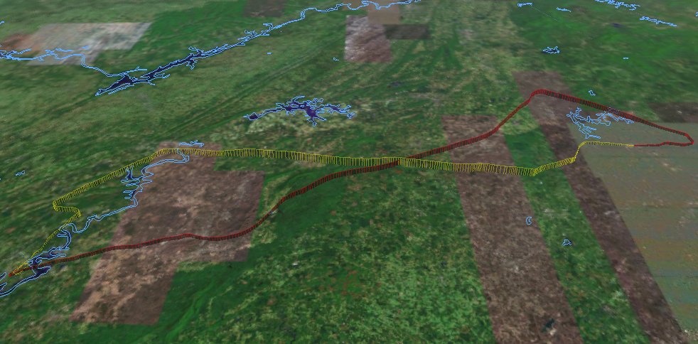
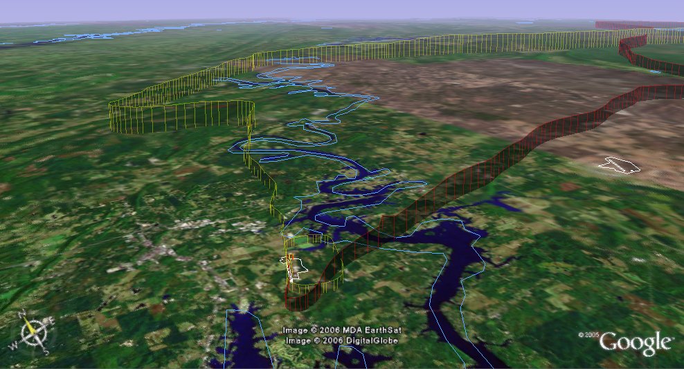
We asked for and were granted the full GPS RWY 20 approach. I put the foggles on and went through my checklists. Pretty standard fare, left 90 degree at the IAF, right 90 degree turn outside the FAF with about a 3 degree glideslope. I got down OK, but the course work was terrible. I never really captured the final approach course and struggled with large serpentine curves. (Mine is the yellow track.) Ouch. Clearly I need more practice.
There were two other planes in the pattern (uncontrolled field) including a homebuilt (Challenger?). When I took the foggles off I could see he was on final infront of us, and felt the spacing was pretty good. I misjudged how slow he was going and executed a go-around when he failed to clear the runway in time. One lap around the pattern for a nice landing at a strange field.
So this was a good trip out to St Clair County airport. We reached 8351 ft (Updrafts through the tops of the clouds) went 131 miles and reached a max ground speed of 141 mph.
C172p
Time = 1.8
Sammie's Touch 'n Go is listed in the $100 Hamburger Guide as the best 2006 Fly-in
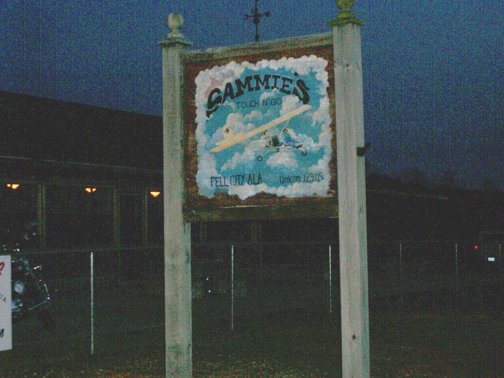 restaurant in Alabama, and you won't get an argument from us. We called the flight school to insure no one had the airplane after us, and to let them know we would be back late. You can taxi right up on the lawn in front for place to park. It is a large 'log cabin' style building decorated with extensive aviation memorabilia. While they opened a bit late, the service was good and the hamburgers were great. Wash it down with a little "sweetea" and you're good to go. Very reasonable price (especially since my copilot paid), it earned every one of the 5 hamburger rating. I'm already looking forward to a return trip with Kathy.
 The trip home was his, night time. He called and got a Wx brief and decided to go VFR to potentially take advantage of an approach at Talladega or Anniston. The front had stalled in southeast Georgia, and there were some clouds in the area, and even forecast for possible thunderstorms there, but our route should be fine. The plan was to fly east , stay south of the restricted area (R2102-A), then head Northeast to Cartersville (VPC) and pick up vectors for the ILS 27 at home.
Startup and taxi were normal ( except going on the grass instead of asphalt until away from Sammie's) and runup was fine. We called a few times to make sure no one was on final, then taxied into position for take off. 5 clicks on the radio and the lights came on. I'm sorry, I think that is really cool and just plain beautiful!

He climbed on course up to 3500ft to the TDG VOR, staying north of the airports and checking in on the CTAF for traffic. Visibility was good and the cloud bases still seemed to be up close to 8000ft. Passing KANB we noticed a 'dark spot' off to our left, and decided to stay clear (cloud?). Turns out it was a mountain. The VFR Sectional gives the quad height of 2500, but the IFR chart showed an MEA of 4000. He decided to climb up to 5500 just to be comfortable. Lesson here is that when you feel uncomfortable, do something about it. Going to 55 was a good decision. The rest of the enroute portion of the flight was uneventful, except for the shear beauty of flying at night. I said it looked like the earth was coverd in black velvet with amber jewels sprinkled all over. "King of the world" comes to mind.
We got our squawk but had trouble staying in radar contact. So we accpted an easterly heading with hopes that ATC would pick us up in time to turn us in for the ILS. Not much traffic on a Friday night, so keeping clear of everyone was pretty easy. Sure enough, we got radar contact back prior to AKONE (FAF) and were cleared (VFR) for the approach. Unfortunately, he didn't do much better then I did (serpentine approach) but made a nice landing. 150 miles, got up to 148 mph and a max altitude of 5927 ft.
Time = 1.3
This was a GREAT training flight. Enjoyable company, fine food, and a touch of adventure. Does it get any better the that? (Doubtful)


Sounds like a good workout!
ReplyDeleteRegarding leaning, most 172 POHs say to lean above 3000'. If you don't lean a least a bit during the climb, you're wasting fuel and reducing performance.
If the plane has CHT read-outs for each cylinder, you can be more precise about leaning.
Some of the unburned fuel is cooling the cylinder heads and valves. If the outside air temp is cool, you can lean more aggressively. If the OAT is hot or the engine is running warm, leave the mixture a bit richer.
Interesting flight, thanks.
ReplyDeleteI've got to figure out how to do the Google Earth maps for my flights.
Jim, I use Garmin's MapSource to bring the track into the PC. From there I simply use the "View" menu to kickoff Google Earth. Pretty colrs and 'skirts' can be applied to the track/path using the edit function in GE. Good luck.
ReplyDelete