Monday, December 12, 2005

IFR 9 - More Practice


The objectives of this flight: 1)Build Confidence, 2) Practice procedures.


I linked up with a safety pilot for this flight, another private pilot working on his Instrument rating. His job is to look outside for traffic while I wear the foggles and look inside at the instruments.

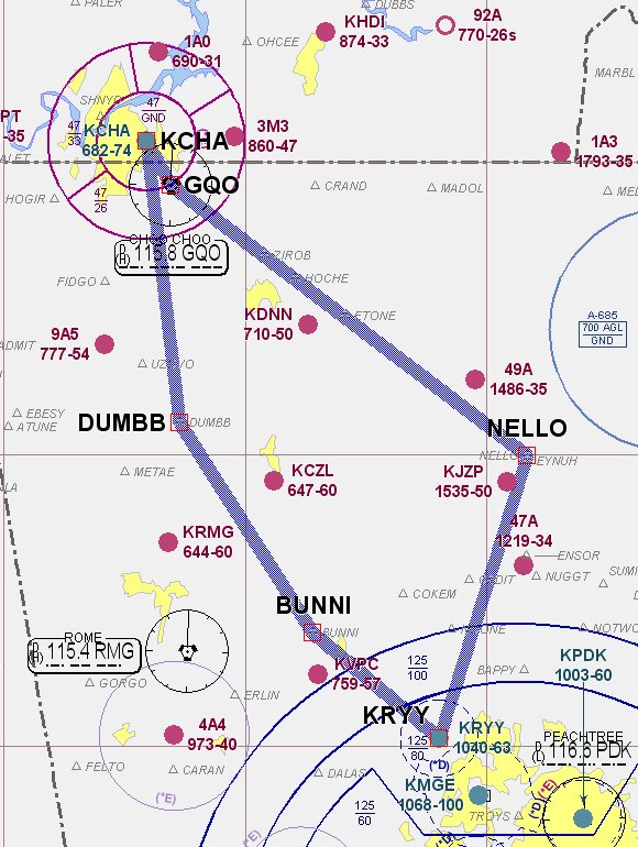
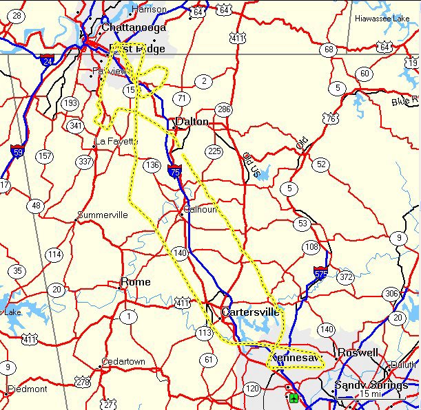
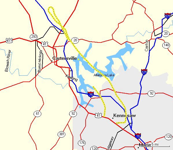
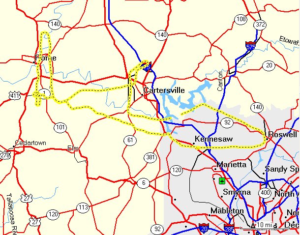
My plan was to fly VFR direct to the Rome VOR, do the the ILS into Russel (RMG), then right over to Cartersville for the Localizer, then back home and ask for vectors to the ILS at Cobb County.

KRMG 121853Z AUTO 29013G21KT 10SM CLR 13/M01 A2990

KRYY 121845Z 29015G21KT 10SM FEW030 12/M01 A2988

The weather was finally good, although gusting winds to 21 knots would make it interesting. I didn't file a flight plan as most of the work would be around non-controlled fields. The brief, preflight and taxi all went well. It is a little different being in the plane without an instructor, more personal responsibility, less effort to impress. I just felt more comfortable. The safety pilot pointed out things he does a bit different, I shared my procedures, and overall it was a very good 'give and take'. Low voltage light during run-up, avionics off (GPS flight plan lost), master reset, voltage OK.

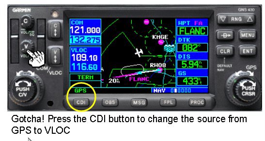
After we cleared Cobb County airspace I put the foggles on and set up to track inbound to the VOR. Along the way I set up the radios, listened for weather, listened to and advised Rome traffic and generally completed all of AMICEATM. I used the GPS as backup and rediscovered my tendency to apply yoke pressure when fiddling with the GPS. I'm just going to have to put my left hand in my lap when I tune that thing. Otherwise my air work was acceptable, though far from my best.

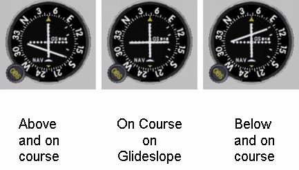
The ILS uses a holding pattern for the procedure turn, the IAF is defined by the inbound course on the Localizer(Nav 1) and a radial from the RMG VOR (Nav 2). My radio setup was good, and it was nice to have GPS setup as backup and situational awareness. (BTW, approach plates are much easier to read in the daytime.) Gusty winds pushed me around a bit, but I felt very comfortable with the approach. Went to mins and executed the missed back to the VOR.

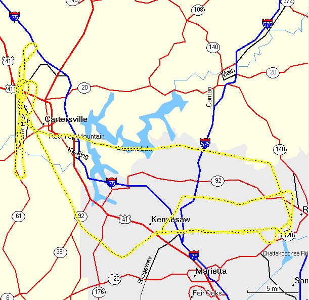
Since I was tracking with Nav 2, it gave me the opportunity to set up Nav 1 for the next approach. Again, I backed this up with the GPS (careful to scan and not push while tuning in the new procedure). Cartersville had touch and go traffic on the opposing runway, so we stayed at altitude for this one. (Again, I was really interested in procedures, so going down to mins wasn't essential.) Normal procedural turn, intercepted the Loc inbound without any problems, took the foggles off so two sets of eyeballs could look out for traffic. Went missed and told the boys in the pattern I would get out of their way.

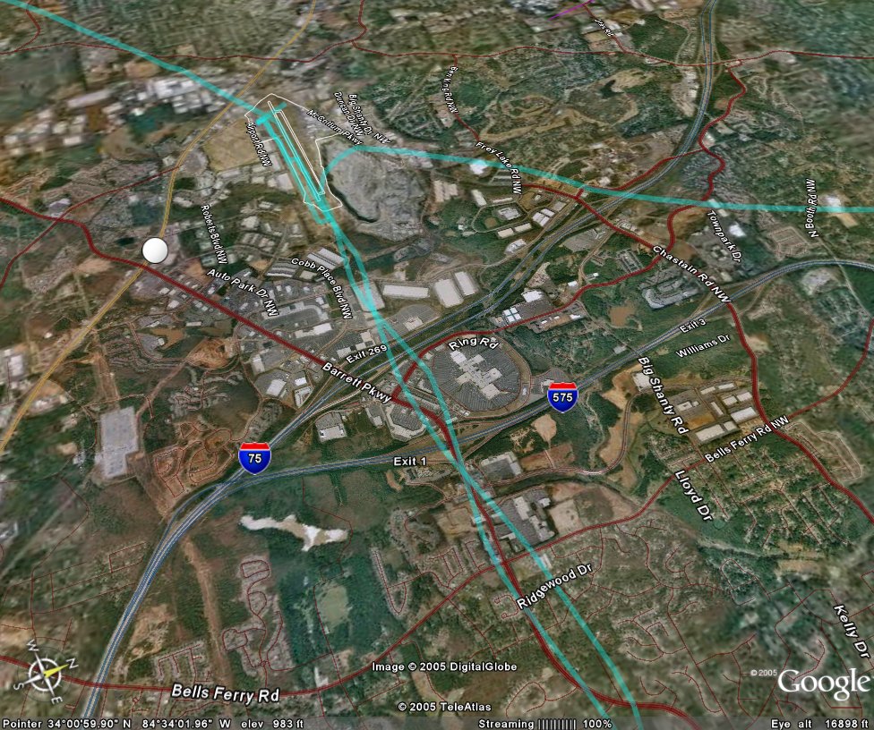
Heading east, the setting sun shining on Atlanta was beautiful. City lights were coming on and the traffic jams coming north made me delighted to be in the sky. I contacted approach to see if they could fit me in for vectors to the ILS back home. It must have been a slow night since he gave me a squawk, told me to stay VFR and gave me the vectors I requested. Foggles back on, checklists complete for a beautiful ILS. Foggles off a little above mins, I saw I had maybe 20 degrees crab into the wind so decided to use just 10 degrees of flaps and fly it a little fast. Landing was not my best, but respectable.

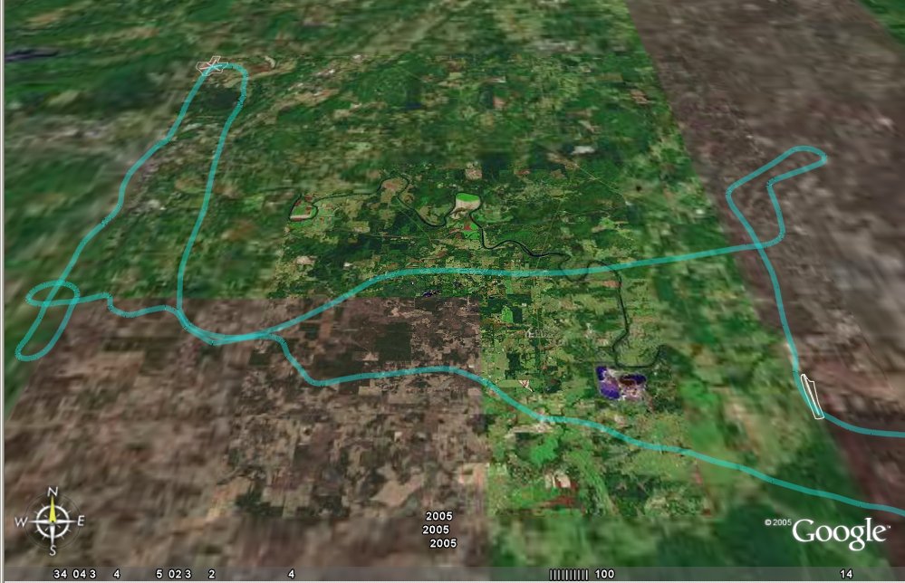
Fun! This was a fun flight. I did all of the things I needed to do, found some inherent weakness in my personal routine that can be corrected, and made a new friend at the same time. We traveled 155 miles, got up to 155 mph and climbed all the way up to 3907 feet. (Scattered clouds at 4500 kept us down around 3000 for most of the flight.)

C172p
Time = 1.7

Thursday, December 1, 2005

IFR 8 - Practice, Practice, ...


The objectives of this flight: Practice. I filed a flight plan to Chattanooga via airways. I planned to do an ILS followed by VOR/DME arc then back home via standard arrival and a GPS.

The planning, preflight and takeoff were all normal. We were cleared as filed, which took us to Nello Intersection then V5 into CQO (Choo Choo) for the approaches at KCHA. Two weeks since the last flight, I was a little rusty, or at least not as sharp as I would like. I had to work to track the course, maintain altitude and make the radio calls. The course deviation never got close to pegged, but it was seldom in the donut either.

CHA was pretty busy and I had vectors for spacing before getting on the approach. I was slow to flip the LOC frequency from standby to active and had a difficult time reading the minimums for the approach. (I discovered something here. I've been using a red LED flashlight for my night flying. For whatever reason, when I use that I can't quite focus on the approach plates. Using a standard red flashlight works better for me.) Good course and glideslope, but I missed at the Localizer mins instead of the ILS. (Dummy)

OK, so executed the missed approach and went for the VOR arc. Osily (IAF) is 7 miles out on the 090 radial, and you arc to the south for a 332 final approach course. Winds were quite strong out of the west, so I used a 20 degree cut instead of the normal 10. It worked well. Course control on final was good. Missed there and turned for home.

The air was much smoother on the way home. Basic air work was much better. I asked for and was given the Bunni Two Standard Arrival (STAR), which took us right by RYY. The GPS 27 was good with a nice landing.

Overall it was an OK flight. I was not happy with my air work. It was a good training flight. Nice to go somewhere different, and a great opportunity to review cross country procedures. A little more practice and I should be ready for the IPC.

251 miles round trip, 5047 feet (always just a bit off), and with the tailwind on the way home we got up to 172 mph.

Cessna 172p
Time = 2.6

Friday, November 18, 2005

IFR 7 - Just one of those nights


The objective of this flight: 1) Practice and review. I wanted to get some ground school done, primarily to review Federal Aviation Regulations (FAR Part 91), Aeronautical (Airman's) Information Manual, and Low Altitude Charts and Approach Plates. After that, I wanted to fly a few ILS approaches just for 'polish'. I'm feeling comfortable now, and just wanted to finish off any items prior to the IPC (Instrument Proficiency Check).

The briefing went well. My study of the manuals paid off, and I reviewed the DVD from Sporty's on the IPC. No questions surprised me, and we discussed common sense, practical airmanship as well as what is in the book. (Knowing that you are going into real IMC conditions, what is your minimum equipment list for a Cessna 172?) I missed a lot of questions on the low altitude charts. Everything is on the legend, and I could easily find it there, but probably a good idea not to be searching a legend on the other side of a chart while bouncing around IFR. So, I need to look over that some more.

Question: Is it legal to download approach plates from AOPA or AirNav (or other WWW sources) for use in actual IFR conditions?

We decide to try a PAR into Dobbins AFB. I hadn't done one of those in XX years, so thought it might be fun. Then try some ILS approaches back home and call it a night. KRYY is Notam'd for runway closure at 10:00 PM (local) for repairs, so we need to be back home before then.

So I go out to preflight and it is cold! My planning METAR looked like this, and by 2300Z it was colder:

KRYY 172045Z 34012G18KT 10SM SKC 07/M09

The first really dumb thing; "Normally" I take the key from the dispatch kit and put it on the glare shield. That way it is visible to any maintenance guys, or others walking around the airplane so that they know the twirly thing in the front isn't going to start moving. This time I put it in my jacket pocket. When I removed the pitot cover I put that in the same pocket. Back in the plane, I put the pitot cover in the dispatch kit (so I wouldn't forget about it and take it home with me.) When I got to the START Checklist we spent a good 10 minutes looking for the darn key. It was in the dispatch kit tangled in the flag of the pitot cover.

The rest of the ground procedures were normal. Take off a little squirely due to winds. Contacted Dobbins and found out they don't accept practice PARs for security reasons. OK, I can understand that, but its too bad.

Plan B: My instructor would like to shoot an approach and asks if I would mind being his safety pilot. GREAT! An education in itself watching his setup and execution. It really helps to drive home all of the tips and techniques he taught me, by seeing him using them to such good effect.

After he gets done, its my turn. Foggles on, approach plate ready, time for the ILS 27 at RYY. He asks me to contact ATC and request the approach. This is easy now, and all communications go well. (BTW, it really does help to have an active noise canceling headset.) Radar contact, on vectors for the approach. AMICEATM

Second really dumb thing: The 'C' in the gouge is for Course. I missed it. I checked it on the approach plate but never dialed it into the CDI. So I'm happily plowing along on vectors, "Cessna 361 turn right heading 240 intercept the final approach course you're cleared for the approach". Course deviation for the Localizer is alive, I turn to....the course from the previous approach, 183. CFI says I'm confused. Center says I'm well south of approach course and asks if I need vectors back. The light bulb comes on. "Center, 361, no thank you sir, I can find it." 30+ correction back to course and by this time the Glide slope is coming alive and the course needle is unpegged. "361 remain VFR, switch to tower Frequency." I'm scrambling. Aviate, Navigate, Communicate. Come left to final approach course, power off to start descent, did I miss anything else? Punch the button to bring up Tower. "Tower, Cessna 361 is with you at AKONE (FAF) ILS RWY 27 with information November. 361 Tower, what are your intentions following this approach? 361 will execute a missed approach for another ILS 27. 361 what are your missed approach instructions?" What, is he testing me too? OK, I know this; "Tower 361 will turn right 030 climb to 3000 feet and contact Approach on 121.0" It was not a test, evidently ATC had never made the complete hand off to Tower.

OK, so that one was ugly. CFI asks if I want to try to redeem myself. Redemption is a good thing. Next one goes OK. A little chasing at the end, I think due to winds, but definitely would have been able to land from real IMC.

Humility is a good thing. Just about the time you think you have this stuff wired, you get a 2x4 to the side of your head. Bad flight, GREAT(!) training flight. We covered 146 miles, reached 143 MPH and an altitude of 4448 feet.

Cessna 172P
Time = 1.2

Saturday, November 12, 2005

Autumn Color

The objective of this flight was very easy: 1) Go north to the Georgia mountains and see the fall colors. N53361 is in for an annual inspection, so I got switched to N737SA, another 172P but without a GPS. It was definitely not required for this flight. Nate called from Cedartown, he had just finished sky diving and wondered if we could pick him up. I was sure that with full tanks, the three of us, and his gear, that the weight and balance numbers wouldn't work.

We were a little late getting to the airport, and as it turned out, the plane needed gas which got us out later then I had wanted. Preflight was normal, but the radio stack was a little different so it took me some time to figure out how to set the frequencies needed for ATIS, ground and tower. The air temperature was a little cooler today, mid 60's, and clear blue sky. Taxi and runup normal, and I decided to let Kathy try a take off. Smooth power, a little rough on the rudder and nice take off attitude. Pretty good for her first attempt. We departed to the north at 2500 feet roughly following I75.

There wasn't as much color as I had hoped for. Maybe because of the low angle of the sun, but the trees were mostly brown and green, not the oranges, reds and yellows I had expected. I let her fly most of the time, no problems encountered. After about twenty minutes she did a 180 and we headed for home. The setting sun illuminated the glass buildings in Atlanta making them seem almost on fire. Entered the pattern on an extended left base and finished with a beautiful landing.

The Flying club was having a Turkey Fry, so we met with Nate for a great dinner. My kind of ambiance, sitting in a hanger watching airplanes land.


The 96c is working better, but still didn't get a complete track.

C172p
Time = 0.7

Thursday, November 3, 2005

IFR 6 - Communicate

The objectives of this flight were pretty simple, 1) Work with ATC. This time I checked the winds BEFORE chosing what approaches I would try. The GPS arc at LZU still looked interesting, and an ILS is always fun, and back home I could do a simple GPS.

Th flight plan looked like this: Depart KRYY then JOXUV KLZU FLANC KFTY UPHAH then back to KRYY. JOXUV, FLANC and UPHAH are initial approach fixes for what I had chosen.

Brief, preflight, and clearance delivery went fine. The interior lights are still a problem, so we broke out the flashlights again. I was cleared Radar Vectors as filed, climb and maintain 3000. Take off went fine, on with the foggles!

The first approach was the GPS RWY 7 at Briscoe Field (LZU). Radar Vectors means just that, we went well past JOXUV before getting cleared back to it due to heavy traffic. No problem though. What happens when you pass JOXUV and start the arc? Distance will be to the next waypoint, not the center of the arc (in this case PDK). MSG tells you to update course, and if you fly that course it pretty much keeps you on the arc, neat! Not so neat is pushing the OBS instead of the MSG button halfway through, because that suspends the procedure. To correct, go to the Flight Plan page, select the arc and enter. Presto, back on the approach. (BTW, using a flashlight to find little GPS buttons while looking through foggles and bifocals at night is a real trick.) The rest of the approach was routine, missed there and headed toward FLANC.


Well, kinda, because I was still on vectors. It gave me plenty of time to set up for the ILS RWY 8 at Charlie Brown (FTY). I learned something here too. Even though trimmed up nicely, I lost about 150 ft while doing 'A mice ATM' for the next approach. While distracted I had a tendency to gently push on the yoke (positive contact - lesson learned; adjust scan and don't push). The other 'gotcha' is what Linda addressed in her blog. "I have finally resorted to teaching the acronym TITS -- standing for Tune, Identify, Twist (the OBS)and Select the source of input data". I decided to include it under my identify step in 'mice', but the point is, you must know what source is driving the navigation head. I still had it set for GPS and needed to switch it over to VLOC for the ILS approach.

OK, nothing tricky here, just follow the instructions and get vectored around to the final approach course (082). Once headed south the CFII pulled out the instrument covers for partial panel. OK, the key here is to remember timing. Approach vectored us to 140. (180 -140 = 40 or about 15 seconds. Check compass. Pretty close!) "Come left heading 120 intercept final approach course you're cleared for the approach." (140 - 120 = 20 or about 10 seconds. Not bad.) The needles are alive! (120 - 82 = 38 or about 15 seconds. Pause and see what the needle says.) Right of course, turn left count 1, 2, 3 stop turn, wait. Right of course, on glidepath reduce power to 1700 RPM turn left count 1, 2, 3 stop turn, wait. On glidepath and the needle is coming back in for course. Hold wings level wait.....wait...Above glidepath left of course, speed is slow, lower nose back to 90 knots, right turn count 1, 2, 3 wait. On glidepath on course, wait... wait, above glidepath on course, reduce power 100 RPM wait. On speed above glidepath take off another 100 RPM wait. Needle stopped moving but not coming back, another 100 off, right of course, turn left count 1, 2, 3 wings level, wait. Decision height execute missed approach, turn left heading 300 climb to 3000. OK, now what is the math? (Target heading minus Final approach course is 300 - 082 = 140 or about 45 second)...did you start the clock, yep. Nailed it!

Vectors for the GPS RWY 9 back home was uneventful. Took the foggels off at mins, slightly left of centerline. And oh, what a beautiful landing!

Great flight. I was especially pleased with the approach at LZU, since it taught so much about the Garmin 430. I'm getting very comfortable with this now.

The 96c failed to provide a track again. I'll put it on the glare shield next time.

172p
Time = 2.0