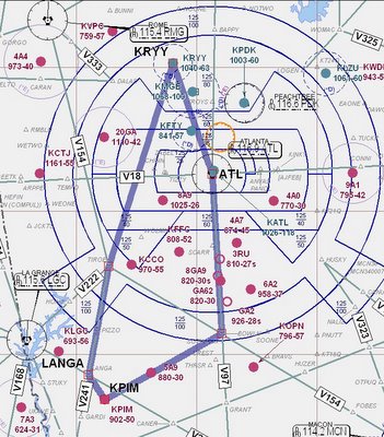
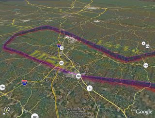
 Objective of this flight: Get away from the patch and work the system. The plan was to fly down to Pine Mountain (Calloway Gardens) KPIM, shoot a GPS approach, come home over Atlanta for ILS 27 at McCollum (KRYY). We used to call them TCAs (upside down wedding cakes) reserved for the busiest of airports. While I've worked with Atlanta Center many times, this would be my first venture into the crowded airspace all by myself.
All the planning was done at home, my first time filing a flight plan
 from my home office. Weather was perfect VFR, not a cloud in the sky and very light winds. I got to airport just before 4:00, got the dispatch kit and went out to preflight. I had planned a 2130z departure, so had plenty of time to set up the radios. I expected a far different clearance from the one filed, so prepared myself to make the changes. To my surprise, I was cleared as filed, fly heading 260, climb and maintain 3000, expect 4000 ten minutes after. Cool.
Taxi, runup and takeoff were all normal. switched to departure, hit the ident button and waited. He was busy, but I always wonder how long to wait before reminding ATC that I'm waiting for radar contact. When he did contact me he had me turn to 180 and told me I would be on vectors down to PIM. (So much for the flight plan.)
This is GREAT stuff! Flying alone in Class B, talking to controllers, watching for traffic, just doing all of the 'stuff' I've been training to do.
I planned to do the GPS-A at PIM, which has an initial approach fix called JUKRU. I got a late frequency change and was passing the fix by the time Approach figured out what I wanted to do. No problem, I responded by going direct CARVA (Final Approach Fix) and playing the GPS to make it all happen. No problem on a clear day like this, I had the field in sight early and could easily have made the landing. Missed there and headed for home.
Again, the filed flight plan wouldn't work. Center didn't want me to fly directly over Hartsfield so I was told to go direct MIKEE. Ah, nice to have the GPS now, much easier to dial it in rather then find the defining navaids, set the radials and determine the correct intercept. A few minutes later I'm given vectors again, fly 360.

I asked for and was granted vectors for the ILS. Now this was really nice, as it took me directly over Dobbins AFB and close to downtown Atlanta. Very Cool! The rest of the approach and landing was uneventful. (Really easy when you can see the runway.) 215 miles, 5,090 feet and a max ground speed of 152 mph.
C172P
Time = 2.2 hrs


Hi Dave,
ReplyDeleteI think I fixed my RSS Feed problem. Can you let me know if it's working or not? Thanks!
Wayne
Just stumbled across this blog. Nice work! I really like the GPS maps.
ReplyDeleteI am trying to add your feed (which I think should be: http://daveslogbook.blogspot.com/atom.xml), but the feed doesn't validate in my reader.
Let me know if there is another feed I can try.
Thanks,
Ben
Hello Ben...hmmmm, I really don't know. I've run into similar problems with other blogs, and am disappointed that you've found a feed problem with mine. I use Firefox (NewsFox) and Thunderbird as my news readers, and they both seem to pick up my feed. (http://daveslogbook.blogspot.com/atom.xml) What reader are you using?
ReplyDeleteDave, I'm using Google Reader (reader.google.com), but checking out your link at FeedValidator FeedValidator for Dave's online logbook shows that it doesn't validate. It's probably more of a problem with Blogger, than with your blog specifically.
ReplyDeleteI don't think it will stop me from stopping by, but it would be nice to have it in Reader.
Thanks,
Ben
I'm not much of an HTML kinda guy, so the validate screen is a bit beyond my capabilities. At first glance it seems that Blogger has a down version of Atom. Don't have the foggiest idea what to do about that. Hopefully it will get fixed soon, but in any case I'm glad you stopped by...y'all come back now.
ReplyDeleteDave,
ReplyDeleteThanks for the post on my site. I used to use magnalox for extracting the tracks from my GPSmap 296 but eventually I found that the newest version of MapSource can export a GPX file. GPX can be read by Earth directly so that saved me from having to use magnalox for the translation.
BTW, your feed seems to work fine with Bloglines - i just added your site to my blogroll there.